Backround
On February 11, neighbors gathered at the Village Green Pavilion to review draft findings from an outsourced transportation study focused on MD Route 210 and the road network that connects our town to Naval Support Facility Indian Head. The study matters because this corridor is not just a commute route. It is where daily life, local business access, school traffic, emergency response, and a major national security mission intersect.
We were there to listen, take notes, and help our community understand what this effort is trying to solve, what is being proposed, and where residents raised feedback that we believe has real merit.
How this post is organized: We break the update into three layers so it is easy to follow and easy to share.
Reference links (as provided):
- Tri-County Council for Southern Maryland (TCCSMD) Study page
- Scope document used to commission the outsourced study (PDF)
Note on sources: This article summarizes (a) the scope and background described in the public PDF used to commission the outsourced work, and (b) draft poster boards displayed at the Feb 11 open house that we photographed at the Village Green Pavilion at approximately 6:00 pm.
1) What the study set out to do
A shared corridor problem, with growing pressure ahead
The study is meant to help our community and the installation plan for safety, access, and emergency preparedness along the corridor that serves both the base mission and daily life in town.
A key backdrop is that NSF Indian Head is in the early stages of a $2.1 billion Energetics Comprehensive Modernization Plan, as stated in the scope document. That level of investment signals more activity, more workers, and more daily trips. In plain terms, we should expect traffic demand to rise, and we should plan for it now, not after the fact. (Source: PDF above)
The scope document also notes that the local road network already supports tens of thousands of daily trips tied to base personnel, contractors, and commercial vehicles, and adjacent resident activity and that substantial increases are expected as modernization continues. (Source: PDF above)
What the study aims to produce
The work is framed to address practical, local outcomes, including:
- Safer and clearer driver approach to a controlled access area
- Reduced congestion and spillback near gate-adjacent decision points
- Better coordination for emergencies and evacuation scenarios
- Concept level alternatives with planning-level costs and a roadmap
- Public communication sessions so residents can see, react, and influence what happens next
(For full scope language, see the PDF link above.)
2) What the draft poster boards showed on February 11
All slide images referenced below are VOIH photos of the poster boards displayed at the Village Green Pavilion.
A) Risk and vulnerability summary, the draft emphasis
The “What We Found” board described a corridor where:
- Congestion and spillback occur near the Main Gate and Pass and ID area
- Driver expectations shift abruptly between a town center setting and a military entry setting, increasing confusion and unsafe maneuvers
- Jurisdiction and ownership clarity, especially near the gate area, affects what can be designed, funded, and built

B) How alternatives were screened
The boards describe a three-bucket decision approach:
- Endorsed recommendations, intended to move toward implementation
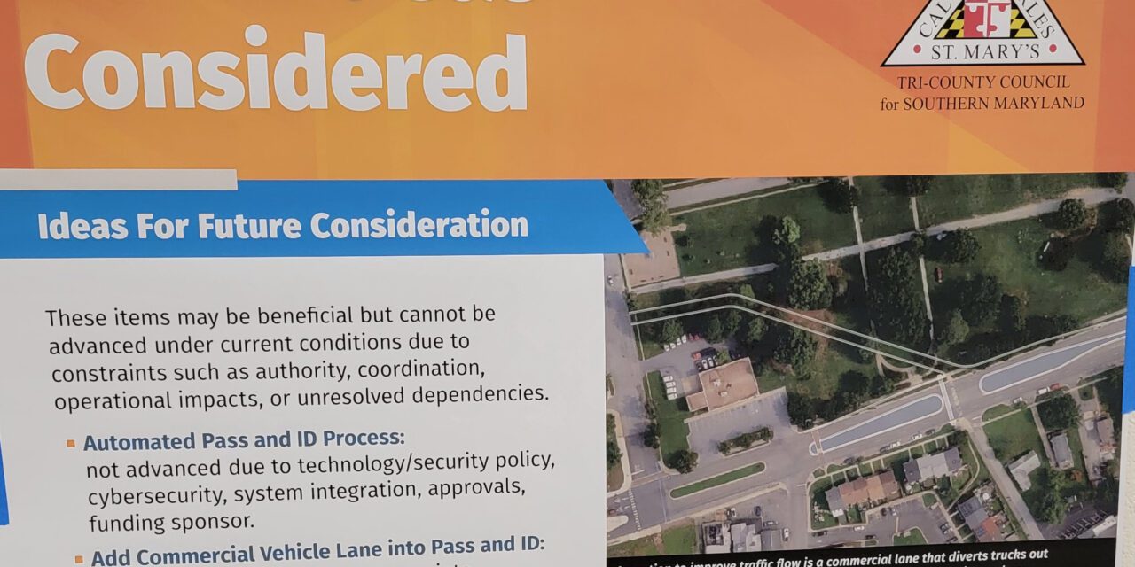
- Items retained for future consideration, potentially beneficial but not feasible under current constraints
- Evaluated but not advanced, documented for transparency
The draft materials also highlight boundary and ownership uncertainty as a practical blocker, and recommend a boundary survey to create a shared baseline.

C) Endorsed recommendations, as presented
The endorsed actions focus on six areas:
- Boundary survey
- Transportation Master Plan
- Pedestrian safety and connectivity improvements
- Speed management and enforcement coordination
- Wayfinding and driver navigation improvements
- A physical roadway geometry cue near the Main Gate, described as a shifting taper concept

D) Implementation roadmap and planning-level costs
The roadmap poster assigns likely leads (Town, County, partners) and rough order-of-magnitude costs across near-term through multi-year timeframes, including a planning-level figure in the hundreds of thousands for the shifting taper concept.

E) Spotlight concept, shifting taper near the Main Gate
The shifting taper poster frames the core issue as a lack of a clear physical transition that signals a public roadway is ending and controlled access is beginning. It proposes a roadway reconfiguration to create that cue, reduce speeds, and improve pedestrian refuge space.
F) Other ideas considered, including the post office
This board matters because it shows some ideas were discussed but not advanced. Notably, it lists “Relocate Post Office” as evaluated but not endorsed, with reasons tied to limited local control, federal decisions and funding, and uncertain feasibility or timeline.

3) What residents raised in public feedback, and where we see strong merit
We captured public feedback during the open house. The themes below are not final conclusions of the study. They are resident observations and suggestions. We believe several of them are sound, practical, and deserve a stronger look as the study moves from draft posters toward an actionable path.
A) Compare lower cost safety cues alongside higher cost geometry changes
Residents accepted the general problem statement, but asked a fair question: Were lower cost physical cues considered and compared in a transparent way?
Examples raised include rumble strips and enhanced flashers. The point is not that these are automatically the right answer. The point is that when we are talking about six-figure and seven-figure changes, the community deserves to see the full menu of options, including simpler treatments, and the tradeoffs for each.
Our view: This is a strong request. Before anything is decided let alone built, residents should see side-by-side comparisons of effectiveness, cost, and operational impact for the entrance versus the implications for residents and normal citizen transit patterns.
B) Protect daily town movement, not only gate operations
Residents also raised concerns that some geometry changes to the lane/median configuration could unintentionally worsen daily backups, especially during morning ingress, and that those backups already ripple through town. Two lanes today already push backups along MD 210 into the rest of town. A configuration requiring a zipper merge in advance of the gate (which itself has two-lane configuration) would likely compound backups unnecessarily, resulting in substantive traffic impacts for residential travelers attempting to access MD 210 from intersections east/north-east of the gate, beyond those already experienced.
Our view: Any recommended concept should clearly show peak-hour impacts for both installation traffic and local residents, projected further out (analysis all the way toward MD 225, far beyond the current study’s limited scope). That includes north-side and south-side turning access, not just what happens at the gate.
C) A signal at Mattingly Avenue deserves serious evaluation
A concrete idea raised was a traffic signal at Mattingly Avenue or a similar flow control measure that creates periodic gaps, improves turning opportunities, and provides a clear visual delineation near the controlled access area. If you’ve attempted to turn onto MD 210 during a lunch or end-of-shift egress from the base, you know quite well that the traffic flow is contiguous, and that wait times to execute a turn can at times be up to ten minutes during peak flow based on our experience. Increasing egress traffic from the base without any periodic delay injection (e.g., a traffic light at Mattingly) results in an impenetrable stream of base traffic, and residential side roads blocked.
We are comfortable saying this directly: this feedback has strong merit. A signal is a familiar tool, it is measurable, it can be tuned, and it has the potential to improve safety and access without requiring large physical changes to shared community space.
Our view: We encourage the study partners to evaluate a signal option seriously and transparently, including how it affects queueing, pedestrian movement, and emergency response.
D) The post office question should be revisited, and treated as a real corridor opportunity
The draft boards list post office relocation as not endorsed, largely due to coordination and feasibility constraints. More specifically, per the Q&A there’s confusion as to who actually owns the land itself (i.e., the Town vs. the US Government), and the US Postal Service was not responsive to the study coordinator’s requests for engagement and consideration. These barriers resulted in this option being filed in the “not endorsed” category because the pieces an stakeholders were outside the study’s realm of control. Most residents understood the contractor’s challenges in wrangling government agencies in this regard, but failed to give government a pass when the impacts of complacency resulted in proposals that unduly impacted local residents.
In rebuttal, residents raised a different perspective that deserves serious consideration: the Pass and ID office sits just adjacent to the Main Gate, and the post office sits just across the street near the Mattingly Avenue intersection. In other words, the post office footprint is not just “nearby.” It is part of the same tight decision zone where traffic stacks, turns, and conflicts concentrate.
We agree this deserves more than a convenient dismissal. Not because it is easy, but because relocating the post office could unlock a meaningful reconfiguration opportunity without requiring the same level of disruption to shared community spaces like the Village Green.
Our view: We encourage continued, respectful, persistent engagement with federal partners. If relocation is difficult, the community still deserves clear answers on what is possible, what is not, and why; and our County, State, and Congressional leadership should be asked to voice opinions on the matter.
E) Expanding controlled footprint near Pass and ID, a practical concept worth exploring
Seen together, these two ideas are really one: if the post office were relocated, the installation could potentially leverage the expanded footprint around the Pass and ID area and the Mattingly intersection approach to relieve entry area congestion and create more options for safer, more functional configuration of the gate-adjacent space.
There are real questions here about land ownership, right of way, and authority, and the draft materials themselves point to boundary uncertainty as a foundational issue.
Our view: This is exactly why the boundary survey is not just paperwork. It is a prerequisite to solving the corridor the right way. We encourage partners to treat right-of-way clarity as an urgent enabler, not a background detail.
A note about public input, and how we can strengthen it
At the Feb 11 open house, questions were answered and commentary was heard. We appreciate that. We also did not observe any visible mechanism for capturing comments in a documented way, such as written comment forms, a posted comment process, or notes taken in the room.
We are not making assumptions about intent. We are simply stating what we saw.
Our encouragement: For future sessions, we hope to see clear, accessible methods for residents to submit comments that become part of the public record. That is how trust grows, and how good ideas survive beyond the room.
What happens next, and what we encourage residents to do
This corridor affects everyone, families, seniors, small businesses, base workers, and the children walking near the Town Center.
Here is our practical encouragement:
- Review the draft boards when they are posted, and form your own view
- Ask for side-by-side comparisons of lower cost cues vs major geometry changes
- Ask for peak-hour modeling clarity that includes town access, not only gate operations
- Speak up in support of options that protect community space and improve safety, including a Mattingly signal evaluation and serious re-engagement on the post office footprint
- Request a documented public comment process be explicitly included in future meetings of this kind (too late for this report as it is expected to reach final publication by month’s end).
We can support what is right for Indian Head while staying respectful, factual, and solution-minded.
Together, we build a better Indian Head.
Source references
- Tri-County Council for Southern Maryland (TCCSMD) Study page
- Scope document used to commission the outsourced study (PDF)
- VOIH photos of draft poster boards displayed at the Village Green Pavilion, Feb 11, 2026 (inserted above as placeholders)